Apple Maps Vehicles Collecting 'Street View' Data in US, UK and IrelandApple has published a
support document on its website confirming that it has been using a
fleet of vehicles to collect street-level imagery for Apple Maps. Apple outlines that it will blur faces and license plates on images, as Google Maps does for Street View, and lists where Apple Maps vehicles will be driving in the United States, England and Ireland between June 15 to June 30.
"Apple is driving vehicles around the world to collect data which will be used to improve Apple Maps. Some of this data will be published in future Apple Maps updates. We are committed to protecting your privacy while collecting this data. For example, we will blur faces and license plates on collected images prior to publication."
Apple has been driving around fifth-generation Dodge Caravans equipped with LiDAR camera equipment on the roof to collect street-level imagery in the United States, starting with major cities and metropolitan areas in the south, northeast and midwest regions of the country. The mapping vehicles have been spotted in at least a dozen states to date as they continue moving further inland.
<img src="
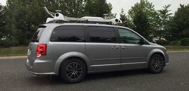
" alt="Apple Van New Jersey" width="800" height="385" class="aligncenter size-full wp-image-452375" /><center>
Apple Map vehicle collecting street-level imagery in New Jersey in May 2015</center>
MacRumors has been tracking Apple Maps vehicles in the United States for the past several months, with the first sightings occurring in New York City in August 2014. Since then, using verified photos with GPS metadata, we have confirmed Apple Maps vehicle sightings in Atlanta, Chicago, Dallas, Los Angeles, Phoenix, San Francisco and many other areas. Many of those locations are listed below.
<img src=" " alt="Apple Maps Vehicles" width="690" height="361" class="aligncenter size-full wp-image-453690" /><center>Click on the map for an interactive view of Apple Maps vehicle sightings in the U.S.</center>
 <li>Anaheim, California
<li>Atlanta, Georgia
<li>Chicago, Illinois
<li>Dallas, Texas
<li>Las Vegas, Nevada
<li>Los Angeles, California
<li>Maui, Hawaii
<li>Miami, Florida
<li>New York City, New York
<li>Orlando, Florida
<li>Palo Alto, California
<li>Phoenix, Arizona
<li>Salt Lake City, Utah
<li>San Diego, California
<li>San Francisco, California
<li>Sunnyvale, California
Apple confirms many of these locations in the support document, while adding Oahu, Boston, Detroit, St. Louis, Seattle, Tucson and surrounding counties as additional U.S. regions it will be surveying in the second half of June. Apple Maps vehicles will also head overseas to collect street-level imagery in Birmingham, Dublin, Essex, Kent, London and several other cities and counties in England and Ireland.
The collection of street-level imagery is part of Apple's larger shift towards
in-house mapping data, in order to reduce its reliance on third-party companies such as TomTom, which has provided data for Apple Maps since it launched. Apple is also allegedly taking photos of businesses, storefronts and other points of interest to replace photos currently provided by Yelp and other third parties.
<small>Send your photos of Apple Maps vans to tips@macrumors.com.</small>
Recent Mac and iOS Blog Stories •
New York and Connecticut Officials Investigate Apple Music for Possible Antitrust Violations •
eBay for Apple Watch Launches Today on App Store •
Apple Bumps Developer Test Device Limits to 100 Per Device Type, Including Apple TV •
OS X 10.11 El Capitan Runs on All Macs Capable of Running Yosemite •
Apple Music to Support Saving Playlists and Songs for Offline Listening •
Apple Confirms Activation Lock Safety Feature for watchOS 2 •
Dedicated iCloud Drive App Included Within Settings of iOS 9 •
'Move to iOS' App Allows for No Hassle Android-to-iOS Data Transfer<img width='1' height='1' src='

' border='0'/><br clear='all'/>
<a href="
http://da.feedsportal.com/r/231049311655/u/49/f/648327/c/35070/s/471bb844/sc/28/rc/1/rc.htm" rel="nofollow"><img src="
http://da.feedsportal.com/r/231049311655/u/49/f/648327/c/35070/s/471bb844/sc/28/rc/1/rc.img" border="0"/>[/url]
<a href="
http://da.feedsportal.com/r/231049311655/u/49/f/648327/c/35070/s/471bb844/sc/28/rc/2/rc.htm" rel="nofollow"><img src="
http://da.feedsportal.com/r/231049311655/u/49/f/648327/c/35070/s/471bb844/sc/28/rc/2/rc.img" border="0"/>[/url]
<a href="
http://da.feedsportal.com/r/231049311655/u/49/f/648327/c/35070/s/471bb844/sc/28/rc/3/rc.htm" rel="nofollow"><img src="
http://da.feedsportal.com/r/231049311655/u/49/f/648327/c/35070/s/471bb844/sc/28/rc/3/rc.img" border="0"/>[/url]
<img src="[url]http://da.feedsportal.com/r/231049311655/u/49/f/648327/c/35070/s/471bb844/sc/28/a2.img" border="0"/>[/url]
<img src="[url]http://adchoice.feedsportal.com/r/231049311655/u/49/f/648327/c/35070/s/471bb844/sc/28/ach.img" border="0"/>[/url]<img width="1" height="1" src="
http://pi.feedsportal.com/r/231049311655/u/49/f/648327/c/35070/s/471bb844/sc/28/a2t.img" border="0"/><img width="1" height="1" src="
http://pi2.feedsportal.com/r/231049311655/u/49/f/648327/c/35070/s/471bb844/sc/28/a2t2.img" border="0"/><div class="feedflare">
<img src="[url]http://feeds.feedburner.com/~ff/MacRumors-Front?d=yIl2AUoC8zA" border="0"></img>[/url]
<img src="[url]http://feeds.feedburner.com/~ff/MacRumors-Front?d=6W8y8wAjSf4" border="0"></img>[/url]
<img src="[url]http://feeds.feedburner.com/~ff/MacRumors-Front?d=qj6IDK7rITs" border="0"></img>[/url]
</div><img src="
http://feeds.feedburner.com/~r/MacRumors-Front/~4/eBLxAxvmaLY" height="1" width="1" alt=""/>
Source:
Apple Maps Vehicles Collecting 'Street View' Data in US, UK and Ireland
